
Whether you desperately need to find a hospital or just fancy a nice evening out, these are the apps to install
Gone are the days when people randomly ambled about an unfamiliar town, looking for somewhere to eat, or had to frantically leaf through a massive phone book when urgently trying to locate a vital service. Now, your iPhone’s all you need to rapidly find local services and points of interest, no matter where you happen to be located.
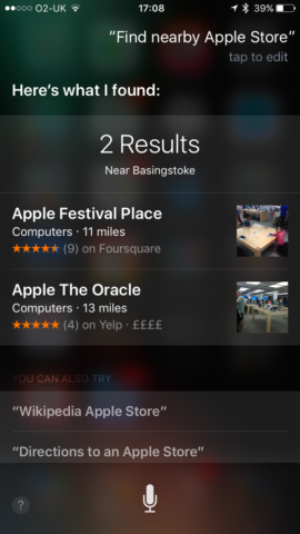
Siri can help with this. Ask Apple’s virtual assistant to “find nearby restaurants” or to give you directions to the nearest hospital, and it should provide the results you need. But Siri can be a bit flaky, and isn’t great at saving things you’d like to revisit later. We’ve therefore scoured the App Store for the best iPhone apps for finding points of interest, whether you’ve a solid 4G connection, or are nursing the last of your iPhone’s battery while in airplane mode.
Poison Maps: Best iPhone POIs app for completeness
$1.99/£1.99 • v3.0.7 • 1.19 GB • By CCS Ltd
Poison Maps needs a lot of space on your iPhone. It’s a truly gargantuan 1.19 GB install, which makes it comparable to high-end games and synthesisers rather than what you’d expect from a mapping app. But what you get in return for that requirement is offline access to a massive 24 million POIs. And no, that’s not a typo – this app really does give you a rapid, searchable, responsive interface for unearthing twenty-four million points of interest scattered across the planet.
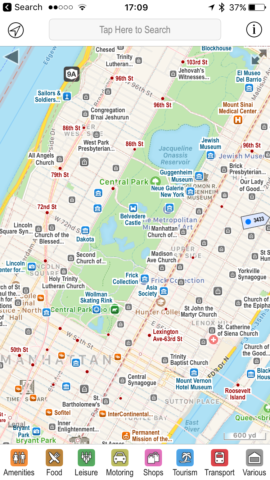
Given that 24 million is a very big number, Poison Maps fortunately helps you quickly hone things down. The toolbar at the foot of the screen has eight distinct categories (amenities, food, leisure, and the like); tap one and everything else is removed from the map. In many cases, you can continue drilling down into sub-categories. Fancy a bite to eat? Tap food. Something quick? Fast food. Then tap something even more specific, and if you have favourites, they can be flagged to prioritise them in subsequent searches.
When searching for items spread over a wider distance, the app showcases some smart design work. The map remains centred on your location, but peppers its edges with arrows that resemble little road signs, showing which way to scroll to find what you’re looking for (and how far away it is). Tap on any item – whether it’s within the current view area or one of those signs – and you can bookmark or pin it; if you’re online, you can also access its details (by way of a Google search) or routing information (using Maps). If there was some way of getting opening hours offline, that’d be nice, but perhaps is expecting a bit much.
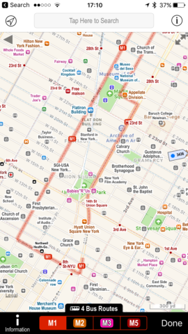
Within the settings are further goodies waiting to be unearthed. The slightly odd compass view probably won’t find that much use (it essentially makes the aforementioned signs bigger and loses the map), but transport overlays are handy for checking out bus and train routes. You can also create your own POIs and delve into the app’s advanced settings. In the latter case, there are options for shake to shuffle (to get new signs), and 3D Touch to quickly zoom out and select a new region to be displayed in the main viewing area.
Assuming you’ve the space on your iPhone, Poison Maps is a great product for rapidly searching the world around you. But if that 1.19 GB download seems a bit rich, the developer has also released a number of smaller Poison Maps apps, which concentrate on specific regions or countries. These also act as demos of sorts, since they’re free with a limited number of unlocked categories. (To unlock the rest, you pay a single one-off IAP.)
(And if you’re wondering about the name, it’s a pun – ‘POIs On Maps’ – rather than someone wishing mapping harm, which would admittedly be a bit weird!)
Google Maps: Best iPhone POIs app for directions
Free • v4.31.1 • 120 MB • By Google, Inc.
Unlike Apple’s Maps app, which seems very much focussed on the ‘maps’ bit, Google Maps has shifted sideways, attempting to be a kind of ‘maps plus’. This is apparent whether you’re just browsing a map or searching for something specific. Zoom into a section of the map (such as a few towns rather than half a country), open the sidebar and tap Explore, and you can quickly check out local places to eat and drink. Alternatively, you can search for something like ‘IKEA in Florida’, to get a list of all of the large blue buildings selling cheap furniture in the Sunshine State.

Because Google sucks information into its maw like a giant vacuum cleaner, any POI you do manage to find likely has a bunch of associated information. Most have a photo, reviews, buttons to trigger a phone call or website visit, and handy information such as opening hours. If you find something you’d potentially like to visit regularly (or at least more easily find again), it can be saved and accessed from any device signed into your Google account.
Naturally, Google Maps also has a distinct advantage over much of the competition in quickly getting you to any places you happen to find. Tap the car button and you’ll get directions to where you want to go, which can be switched between going by car, on public transport, on foot, or by bike.
Although primarily designed for online use, Google Maps has been making inroads into the offline arena. From the sidebar, choose Offline areas, and then Custom area. Pan and zoom to select the area you want to download offline (which can’t be the entire world, but you should be able to grab a city or even an entire region), and tap Download. This area will then be available offline.
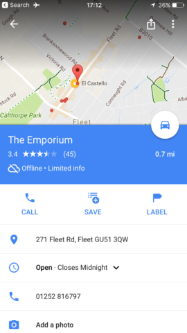
You won’t get access to the entire wealth of information you’d enjoy with an internet connection, but Google Maps’ offline mode is nonetheless impressive. Directions – whether driving or walking – in many cases remain spookily accurate, keeping track of where you are to within a few metres or yards. Moreover, some of the POI stuff will also continue to work. During testing, we grabbed for offline use the area around our local town, and Google instantly listed local pubs, and it was still possible to view their addresses, phone numbers and opening hours.
We suspect in the not-too-distant – when smartphone capacities are larger than they are today – Google Maps will take a note out of Poison Maps’ book and optionally provide all POIs offline. Until then, the ‘compromise’ of being online-only or remembering to store a location offline before going on a journey isn’t exactly arduous.
Triposo: Best iPhone POIs app for sightseeing
Free • v6.1.2 • 129 MB • By Triposo INc
Although it’s possible to use the previous two entries in this list to find interesting things to do for a day out, that’s not what they’re geared towards. You’re more likely to use Poison Maps or Google Maps to find a restaurant or petrol station than a castle, museum, or local curiosity. To a great extent, Triposo flips this on its head.

Type in a location – which can be anything from a large city to surprisingly small towns and villages – and Triposo will load its guide. (50,000 destinations are reportedly available.) From the intro screen, you can then access things to see and do, places to eat and drink, and also places to stay. By default, these are shown in list format, but there’s an alternate map view if you want to get a sense of where things are found.
‘See and Do’ is the most interesting of the mentioned categories. Depending on what’s available in the place you’re searching, you might get nightlife recommendations, lists of attractions, suggestions for shopping, links to local areas for day trips, and more. Tapping an entry will often provide an overview, along with giving you the opportunity to save it and get directions.
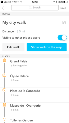
Should you want to string together a selection of places of interest as a walk, Triposo has that covered. Tap the saved places icon at the top-right of the screen and then Create City Walk. Choose whether you want a short or long walk and a plan will instantly be created. This can then be edited, displayed on a map, saved, and shared. (Sign up for an optional account and your data can be synced across multiple devices)
Because this app is a travel guide, it sensibly includes a robust offline mode. Select a location to download, and you’ll be offered one or more options for doing so. One will typically always be a city or region, but some places are also found within a country’s ‘top destinations’ list. Without an internet connection, mapping, routing and city walks remain usable. Whether planning a trip away or already immersed in a new and exciting city, Triposo’s therefore an essential app to have installed on your iPhone.
Also consider…
Foursquare
Free • v10.6 • 76.3 MB • By Foursquare Labs, Inc.

This app’s primarily interested in getting you fed and entertained. It scours your locale, and enables you to prod large buttons to find local eateries, nightlife, or things to do. The app has some pretty robust and usable filtering in place, so you can filter a list’s results by price, opening times, features, whether they’re good for groups or working, and if you’ve visited them before. Most items are rated by users, and many have reviews (including, as we discovered during testing, railway stations). You do, though, need an internet connection to use the app – although it does appear to cache some previously accessed data for offline use.
AroundMe
Free • v10.0.9 • 41.5 MB •By Flying Code Ltd
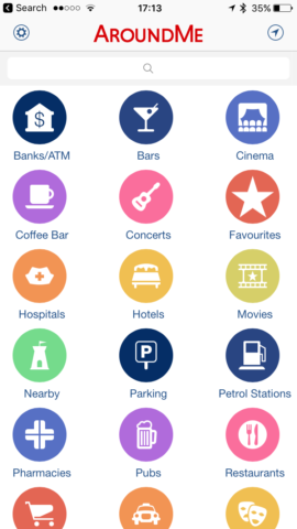
From a functionality perspective, AroundMe is not a million miles away from Poison Maps – only it doesn’t come with a price tag. (Instead, it has adverts.) It also doesn’t come with an offline mode, but it’s a suitably decent freebie for quickly locating local businesses and amenities. On making a search, you get three alternate viewpoints to choose from, too: list, map, and live view. The last of those is an augmented reality option, which attempts to guide you by way of floating tags – although that does require you walk about the place holding your iPhone in front of your face.
V for Wikipedia
$4.99/£4.99 • v1.2.7 • 29.7 MB •By Raureif
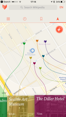
In our Wikipedia apps round-up, we reckoned V was the best premium Wikipedia app for iPhone. One of its more interesting features is a location-based search. On allowing the app to use your location, you get a local map and coloured flags that are attached to tappable blocks that open articles about the POIs in question. This app isn’t going to be much use if you want to quickly find a cash machine or something to eat. But given that Wikipedia only tends to cover things of note, V can be a useful way to virtually explore your surroundings when doing a bit of sightseeing, quickly filtering a location to places deemed sufficiently interesting to get a write-up.